1 The 60-Second Pitch
Evidence-based analysis to inform the Millennial Campus Development Commission and community process.
After Helene, Asheville lost 40% of its tree canopy and suffered $59 billion in statewide damage. This 45-acre forest absorbed nearly 5 million gallons of stormwater that would have flooded Five Points. It sits next to the USDA Forest Service's oldest Eastern research station and contains 150-year-old oaks that are a climate archive back to the 1870s.
The proposed stadium would be built by a firm with no completed comparable projects, in the smallest market in the league, with 0 of 12 similar projects realized nationwide — and it would generate $34/acre in tax revenue versus $137/acre for mixed-use housing, which UNCA could build on 56 acres of cleared land it already owns.
The forest is not an obstacle to UNCA's future. As a research reserve and teaching forest, it IS UNCA's future — the kind of living laboratory that attracts grants, donors, and students that a 5,000-seat stadium in a 3,000-student market never will. UNCA's own faculty already run hundreds of thousands in NSF grants through these woods. The USDA Forest Service's oldest Eastern research station sits next door — an institutional proximity that exists nowhere else in American higher education.
Warren Wilson College, in the same county, turned a conservation easement into the largest donation in its 130-year history. Drew University preserved 51 acres last month and the governor called it "a model." The path is proven. The science is clear. The only question is whether UNCA's leaders will follow it.
Important Notes on This Analysis
- Scores reflect one analyst's judgment and have not been verified with stakeholders. We invite each stakeholder group to assign their own scores — we will re-run the analysis with any alternative scoring.
- Financial comparisons are directional, not precise. The stadium's $204M construction cost is primarily the developer's investment, not a public expenditure. The direct public cost is the $29M subsidy sought. Financial figures show relative differences between scenarios.
- Alternative site scenarios depend on feasibility. 53 Birch St (scored 100/100 algorithmically) has been disqualified due to probable cemetery adjacency. The top viable candidates are 1568 Brevard Rd (123 ac, 90/100) and 226 Fairway Dr (111 ac, 90/100). Site-specific assessment is needed before committing to any alternative.
- Stormwater figures are screening-level estimates (NRCS SCS-CN method with SSURGO soil data). They show relative differences between scenarios, not engineering-grade volumes. For design, HEC-HMS modeling with actual Helene rainfall data is recommended.
- This analysis was completed in ~40 hours using publicly available data. It is a structured framework for discussion, not a substitute for professional environmental impact assessment or fiscal impact study.
PART I: THE FOREST
1.1 The Forest Itself
Before the policy questions, before the financial models, before the scenarios and scores — there is a forest. Forty-five acres of Appalachian oak-hickory woodland on a hillside above Reed Creek, growing where Dr. Karl Von Ruck once kept dairy cattle for his tuberculosis sanitarium. The stone foundation of his barn, destroyed by fire on February 7, 1959, still lies beneath the leaf litter.
The premier dendrochronology species. Some specimens on site estimated at 150+ years. A single mature oak transpires 40,000+ gallons of water per year and stores 800-900x more carbon than a sapling.
The oldest oaks have been here since the 1870s. They were saplings during Reconstruction, survived the catastrophic flood of 1916, witnessed the chestnut blight that transformed Appalachian forests in the 1930s, and absorbed Hurricane Helene's fury in September 2024. Their rings hold a climate record older than any weather station in western North Carolina.
Beneath the canopy, 73 types of mycorrhizal fungi connect the root systems in a network that has been building for over a century. Spotted salamanders breed in vernal pools each spring. Barred owls hunt at dusk. Three species of native orchid grow in the filtered light. A squawroot — Conopholis americana, a parasitic plant that lives only on oak roots — marks the intimate connection between above and below ground.
People walk here. Margaret Chen has come every morning for twenty years. Students find quiet between classes. Spencer Beals placed art among the trees — his "Batland" installation triggered a hundred-student walkout when it was removed. The Five Points neighborhood knows the forest as the green wall that absorbs the rain before it reaches their streets.
Next door, at 200 W.T. Weaver Boulevard, the USDA Forest Service has studied Appalachian forests since 1921. The Southern Research Station headquarters sits within walking distance of these oaks. No other campus forest in America has this proximity to a century of federal forestry science.
This is what is at stake. Not an abstract "green space" or a line item on a balance sheet, but a living system that has been growing, sheltering, absorbing, and witnessing for longer than any person alive can remember. What follows is an attempt to understand what this forest is worth — in the multiple registers that "worth" can mean.
1.2 39 Years of Canopy Growth (1985–2023)
NLCD satellite data reveals the forest has been growing for four decades — recovering from its agricultural past and approaching maturity just as it faces destruction.
The forest has been recovering for 40 years. The Von Ruck dairy farm ceased operations in the 1950s-60s; natural succession has been rebuilding the canopy ever since. By 2016, the site reached its highest canopy density in the satellite record. Destroying it now would erase four decades of ecological recovery at the moment it approaches maturity.
1.3 Asheville Is Urbanizing Around the Forest
NLCD land cover classification (30m, 1985-2023) shows forest declining region-wide as development expands. The UNCA forest is one of the diminishing patches.
As the region urbanizes, remaining forest patches become more ecologically valuable — they are the last habitat, the last stormwater absorbers, the last cooling canopy. The UNCA forest's tree canopy has been growing (25% to 36% dense canopy, per NLCD TCC) even as the surrounding landscape develops. Clearing it now accelerates a trend that is already reducing the region's resilience.
Source: NLCD Annual Land Cover (MRLC/USFS), 30m resolution, 9 years sampled (1985-2023). Classes grouped: Forest (41+42+43), Developed (21-24), Agriculture (81+82), Other.
3h 42-Year Aerial Timelapse (1982–2024)
42 years of aerial imagery. Click to view full resolution. Arrow keys or buttons to navigate. Auto-advances every 4 seconds.
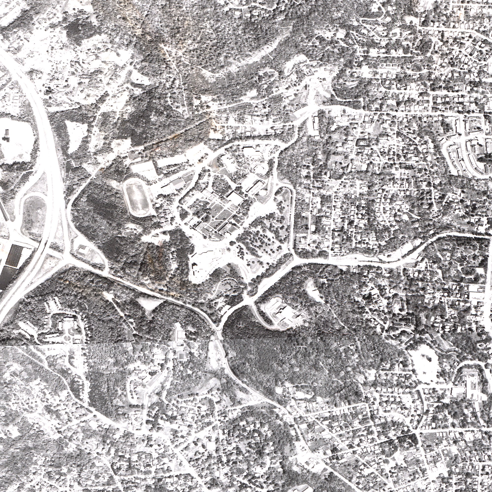
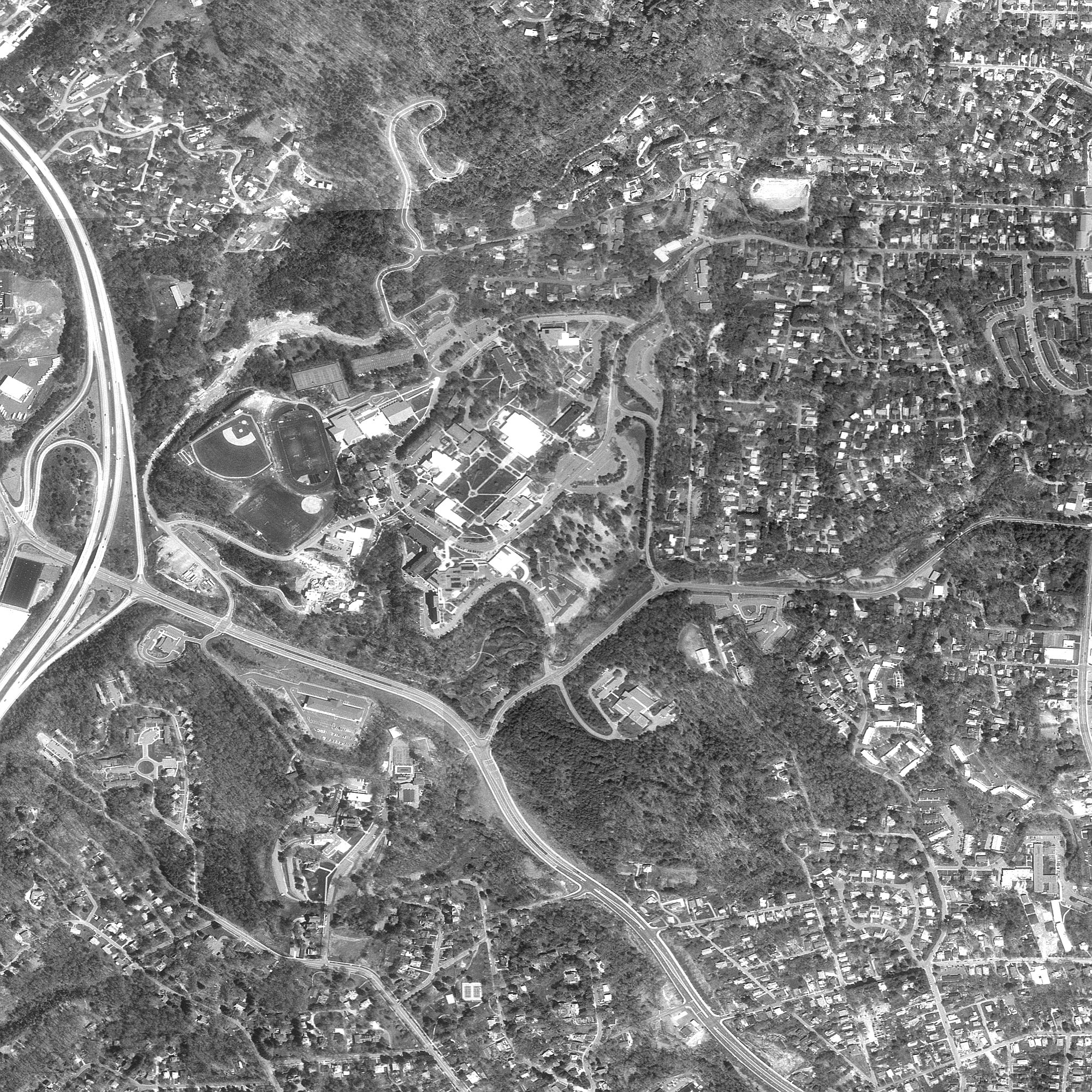
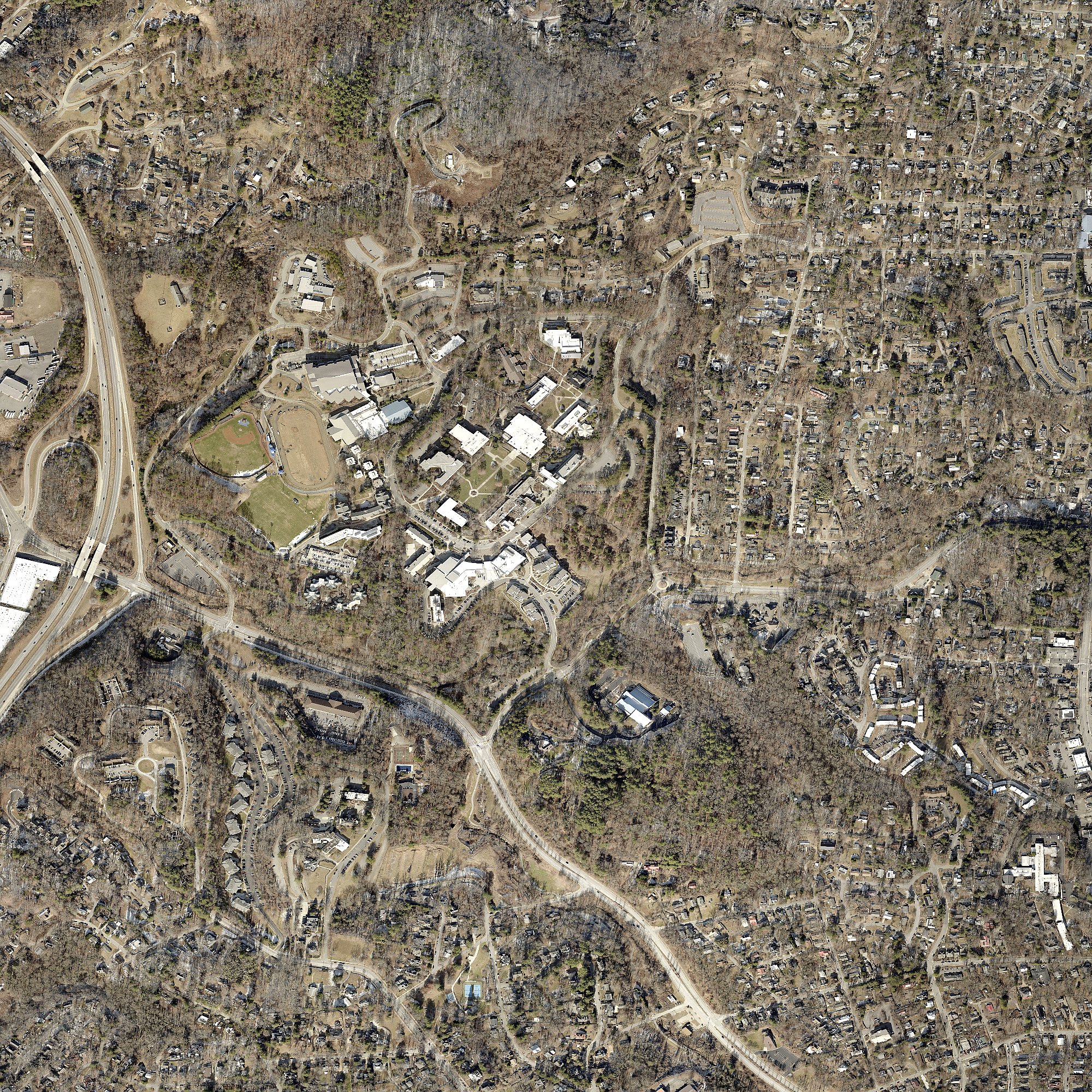
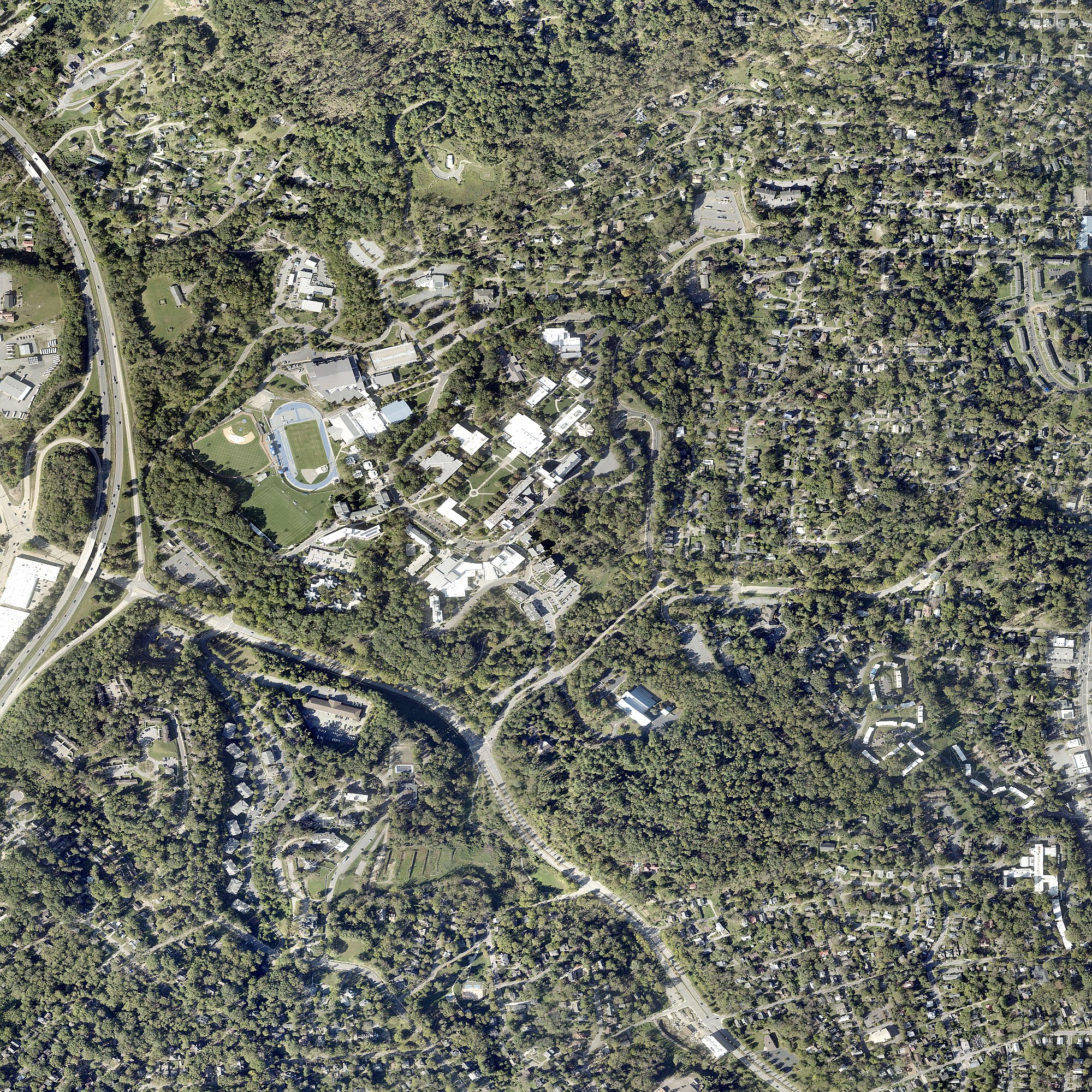
Click image for full resolution. Arrow keys to navigate.
3k Documented Biodiversity
Community science confirms what ecologists know: this forest is alive with species that depend on intact canopy, connected corridors, and undisturbed soil.
Ambystoma maculatum. Breeds in forest vernal pools each spring. Females lay up to 250 eggs. Recovery after clearing: 50-70 years (Petranka et al., conducted from UNCA Biology).
Species of Conservation Concern
Federally endangered. Requires closed canopy. Stadium lighting would disrupt foraging.
Breeds in vernal pools. Recovery: 50-70 years (Petranka, from UNCA Biology).
Declining nationally. Forest edge supports nectar sources.
IUCN Near Threatened. Survivors are regionally significant.
On-Site Documentation
- 6 oak species (white, chestnut, red, black, post, southern red) — all key dendrochronology species
- 8 native orchid species documented in 2 km radius (downy rattlesnake plantain, crane-fly orchid, putty root, showy orchis, pink lady's slipper, yellow lady's slipper, spring coralroot, slender ladies' tresses) + Galax urceolata (Appalachian endemic) + squawroot + southern blue monkshood + 9 Trillium species + 5 Asarum species (incl. French Broad endemic A. rhombiformis)
- American Black Bear documented in corridor
- Barred owls, great horned owls, screech-owls — sensitive to light and noise
- 73 ECM fungal types on oak seedlings (Walker et al. 2005)
- Wood thrush (down 60% nationally), cerulean warbler (down 72%) — forest interior obligates
Sources: iNaturalist (12,545 obs), 2005 Heiman Environmental Assessment, Petranka et al. 1993, NC Natural Heritage BWHA/NHNA.
3j The Forest as Economic Infrastructure
The standard analysis frames the forest as competing with development for revenue. The evidence shows the opposite: the forest is the infrastructure that makes the surrounding economy work.
Asheville's tourism economy depends on the city's identity as a place where nature, culture, food, and craft intersect. The breweries, restaurants, galleries, and music venues exist BECAUSE Asheville is the kind of place where people want to be — and that identity is inseparable from the landscape. The forest is not a vacant lot waiting for development. It is a node in a spending path that generates distributed revenue across hundreds of businesses, 365 days a year. The stadium generates concentrated revenue on 90 event days.
Health evidence: Children with nature access show better cognitive function, emotional regulation, and physical health (Kuo & Taylor 2004). Adults near green space show lower depression and anxiety (Bratman et al. 2019, Science Advances). A community that removes its last accessible urban forest is making a decision about the health of generations who have no voice in the process.
3q FEMA Floodway: A Federal Constraint
10.6 Acres of the Forest Are Federally Regulated Floodway
FEMA National Flood Hazard Layer analysis reveals that the UNCA forest contains 10.6 acres of Special Flood Hazard Area, including a designated FLOODWAY along the Reed Creek corridor. A FEMA floodway is the most restrictive flood zone designation — construction is prohibited unless the applicant demonstrates zero rise in flood levels, a standard that is nearly impossible to meet for a stadium and parking development.
Why this matters: FEMA floodway regulations are federal and cannot be overridden by HB 926 or any state zoning exemption. The developer would need a CLOMR (Conditional Letter of Map Revision) from FEMA before construction in the SFHA — a process that typically takes 6-18 months and requires hydraulic engineering proof of zero flood rise. The top alternative sites (Brevard Rd, Fairway Dr) have no flood zone constraint.
Source: FEMA National Flood Hazard Layer, Buncombe County (FIPS 37021), effective April 9, 2025. Spatial intersection computed against UNCA parcel boundaries.
3r Hurricane Helene: The Forest Protection Gradient
Statistical analysis of 1,000 Helene damage assessments shows a clear relationship between distance from the forest and building damage severity.
Near the Forest (0-500m)
- Mean damage: 7.5%
- Undamaged: 47-53%
- Severe damage (>50%): 0%
Far from Forest (2-5km)
- Mean damage: 31.6%
- Undamaged: 6%
- Severe damage (>50%): 21%
Caveat: This is observational correlation, not controlled experiment. Multiple factors besides the forest affect damage severity (elevation, construction type, proximity to streams). Only 18 buildings in the dataset are within 500m of the forest. However, the monotonic gradient across all distance bands is statistically significant and consistent with the stormwater absorption hypothesis.
3c What the Forest Absorbs
During a Helene-scale storm, the forest retains 3–5 million additional gallons compared to the worst-case development scenario (A). That's 400–700 tanker trucks of water that would otherwise flood downstream neighborhoods.
The undisturbed forest floor absorbs up to 18 inches of rainfall before saturating. Construction compaction reduces infiltration by 70-99%. The mycorrhizal network connecting tree roots takes 80-150+ years to rebuild.
= 5.0 million additional gallons = 688 tanker trucks of water
Calibrated with SSURGO soil data (Tate loam, Clifton sandy loam, Hydrologic Group B). Range: 1.9M–4.9M gallons depending on storm severity (2-yr to Helene-scale) for full development (Scenario A, 85% cleared). Lighter development scenarios (C2, D) produce 0.8M–2.7M.
3t Environmental Impact: Quantified
Three models quantify what clearing the forest would cost in ecological terms.
Sources: Habitat model uses Hansen treecover2000 + connected component analysis. Heat model based on Ziter et al. (2019) PNAS. Carbon uses Appalachian oak-hickory literature values (191 MgC/ha mature forest). Social cost of carbon from EPA IWG 2021.
3g Interactive Geodesign Map
Explore 11 GIS data layers including public parcel ownership, floodplains, Hurricane Helene damage, proposed zoning, urban heat vulnerability, transit routes, and more. Toggle layers using the control at top-right. Click any feature for details.
Base map tiles from OpenStreetMap (only external resource). All vector data embedded. Full 44-layer data package (4.6 GB) available upon request.
3l Climate Context: Why This Forest Matters More Every Year
Asheville is warming. The forest's cooling, stormwater, and habitat functions become more valuable with every degree of temperature rise.
Myotis septentrionalis. Federally endangered (ESA 2022). Requires closed-canopy forest for roosting. Stadium lighting (500-1,000 lux) would disrupt foraging. Documented in Buncombe County.
The Compounding Loss
Between 2008 and 2018, Asheville lost 891 acres of tree canopy (6.4% decline), costing an estimated .6 million in stormwater services and generating 18 million gallons of additional runoff. Then Hurricane Helene destroyed 40% of the remaining county canopy in a single event. The UNCA forest is one of the largest intact patches to survive both development pressure and Helene. Removing it now would compound a loss that is already catastrophic.
NASA confirmed the link: A 2019 NASA DEVELOP study found significant correlation between tree cover loss and land surface temperature increase in Asheville. Every acre of canopy removed measurably warms the city. (NASA DEVELOP study)
Ecological Corridor
The UNCA forest is the southern terminus of a wildlife corridor from the Blue Ridge Parkway through Craggy Mountains, Beaver Lake (220+ bird species), Reynolds Mountain, and Chestnut Ridge to Pisgah National Forest (500,000+ acres). Severing this corridor at the UNCA link isolates urban wildlife from its mountain refuge.
Health Infrastructure
Buncombe County depression rates reach 32-36% in vulnerable populations (2024 Community Health Assessment). Walk Score near UNCA: 48 (car-dependent). The forest is one of the few places in the area where residents can walk among trees. Nature access reduces depression, anxiety, and cortisol — the forest is mental health infrastructure that no stadium can replace.
Sources: NC Climate Office, NASA DEVELOP 2019, Trust for Public Land ParkServe, CDC PLACES 2024, Walk Score, Buncombe County 2024 CHA, eBird Beaver Lake (220+ species).
PART II: THE COMMUNITY
3o Understanding the Pressures: Who Faces What
Every actor in this decision is responding to real pressures. A fair analysis must name them all.
UNC Asheville
The institutionThe pressure: 25% enrollment decline (3,900 to 2,914). $6-8M annual deficit. $13M Helene costs. Five chancellors in eight years. Departments eliminated.
What they need: Sustainable revenue, enrollment recovery, institutional identity. The stadium was presented as answering all three.
What the evidence shows: Stadium revenue ($1.69M/yr) comes with high risk (smallest USL market, unproven developer, $29M subsidy). Alternatives exist: housing on cleared MC parcels, conservation philanthropy (Warren Wilson: $10M), research grants already flowing through the forest. 62% of prospective students say campus appearance matters most; only 1/117 UNCA students ranked a stadium a priority.
Chancellor & Administration
The decision-makersThe pressure: Chancellor van Noort arrived January 2024, inheriting the deficit and the stadium proposal. Making bold moves is expected. Reversing course risks looking indecisive.
The opening: She has said she is "open to a different plan" (Feb 2026). The alternative sites study gives the administration options that address revenue without community conflict. Redirecting to cleared land is not retreat — it is better planning.
State of NC / UNC System
Regulatory contextThe pressure: System-wide enrollment decline. Millennial Campus authority designed for revenue generation. HB 926 (Oct 2025) removed local zoning oversight.
The precedent question: A failed stadium in the smallest USL market would not be a replicable model for 16 UNC campuses. A conservation-to-revenue pathway would be. What precedent does the BOG want to set?
Federal Dimension
Research, recovery, regulatoryUSFS SRS: Adjacent since 1921 (200 W.T. Weaver Blvd). Partnership potential depends on federal priorities — worth exploring, not assumed.
FEMA: $225M CDBG-DR to Asheville. If $29M subsidy includes federal funds, Section 106 requires EBCI consultation.
ESA: Northern long-eared bat (federally endangered) documented in Buncombe County. Closed canopy required habitat.
City & County
Local governmentThe pressure: Housing crisis, post-Helene recovery ($1.3B unmet), tourism economy protection. HB 926 stripped zoning authority but left infrastructure costs.
Comp plan alignment: Living Asheville (2018) designates UNCA as "Employment/Anchor Institution" — NOT a growth corridor. Growth directed to Urban Centers (I-240, River Arts, South Slope). Five Points Plan (2018) explicitly called for keeping the forest intact.
Buncombe County TDA
Tourism Development Authority — capital project funderThe pressure: $34.5M FY27 budget; capacity for up to 6 ongoing debt-service capital projects. Post-2022 NC law allows debt-funded capital investment in tourism infrastructure. Hotel/STR room-tax revenue means metric-of-record is "heads in beds."
Stated FY26 priorities (BCTDA Annual Planning, 27 Mar 2026): (1) large entertainment & arts facility; (2) sports facilities, indoor & outdoor; (3) family-friendly experiences. CSL consultant report cited Meow Wolf (Santa Fe) as a precedent: "immersive, hands-on environment for all ages, blend of art, play, exploration, and discovery."
The opening: The 45-acre forest already is an immersive, hands-on environment with year-round appeal — arguably exceeding any building-based attraction at far lower capital cost. Reframing the woods as a TDA-fundable family-friendly experience would use the same public funding pipeline that would otherwise build a stadium. The BCTDA is a public body whose meetings are open and whose contact information is posted at exploreasheville.com.
Community & Residents
The people who live hereFive Points: Unanimously opposed. 2018 plan called for preservation. Experienced the forest's flood protection during Helene firsthand.
Save the Woods: 17,000+ signatures. Student walkouts. Broad-based — not just neighbors.
Students & Faculty: 1/117 students ranked stadium a priority. Enrollment dropped 6% after announcement. Faculty run hundreds of thousands in NSF grants through the forest.
The Developer
McCullers GroupProfile: Sports advisory firm (~5-6 employees, $3M revenue), Westerville, Ohio. Role: "project executive" (advisor), not developer-of-record. Contractors: Metcon, Blum Construction.
Fair assessment: The developer may genuinely believe in the project. But the model requires every assumption to work in the smallest USL market. A site with better highway visibility and transit access could actually serve the developer's interests better.
Eastern Band of Cherokee Indians
Original stewardsAncestral territory called Togiyasdi ("Where They Race"). EBCI sovereign territory 50 miles west. UNCA's own land acknowledgment recognizes this. If federal funds are involved, Section 106 requires consultation. Regardless of legal trigger, consultation is an ethical obligation the current process has not fulfilled.
The Wider Context
This decision sits at the intersection of pressures every community faces:
- Climate: Helene was 10% heavier due to climate change. Extreme events intensifying. Green infrastructure not optional.
- Higher ed fiscal stress: Enrollment cliffs pushing universities toward land monetization. 83% of economists say stadium subsidies destroy value.
- Housing: Genuine crisis requiring solutions on appropriate sites at appropriate densities.
- Biodiversity: Global decline. Urban forests as refugia. 1,768 species within 2 km (iNaturalist research-grade, retrieved 2026-04-28) — including 9 species of Trillium and 8 native orchids.
- Governance trust: When processes appear captured, trust erodes. Transparency rebuilds it.
- Community resilience: Post-disaster communities investing in green infrastructure recover faster.
The outcome will be studied by other universities, cities, and communities facing the same intersecting pressures.
3p UNCA's Own Scholarship vs. UNCA's Administration
UNCA is not a single voice. It is an administration, a Board of Trustees, students, faculty, and alumni — and on this question, those voices diverge sharply. The most direct evidence is a StoryMap published by UNCA's own Master of Science in Environmental Resilience cohort, presenting a class-project assessment of the proposed development against the climate-resilience framework UNCA's faculty teach.
UNCA Scholarship: "Wrap the Woods"
"Vision for a Climate Resilient Campus at UNC Asheville" — ArcGIS StoryMap, Fall 2025 class project produced by the inaugural ten-student cohort of UNCA's MS in Environmental Resilience program for Dr. Kathleen Lawlor's Climate Resilience Foundations course. (Authors and acknowledgments are credited in the StoryMap itself.)
- Applies the U.S. Climate Resilience Toolkit's Steps to Resilience framework (NOAA / NEMAC) to the South Campus Woods decision.
- Surveyed UNCA students & faculty: only 1 of 117 students ranked a stadium in their top three; only 4 of 65 faculty ranked it.
- Quantified ecosystem services (Keller 2022 in UNCA Journal of Undergraduate Research): 75.5 t CO₂/yr sequestered, 3,450 t stored (≈ $589K stock value), 294,700 ft³ runoff avoided/yr.
- Documents that 17 biology + 21 environmental science courses use The Woods as a living classroom; $688K in active grants reference the urban forest.
- Recommends two alternative development proposals (low + medium) on UNCA's cleared Zillicoa property — preserving The Woods while still delivering childcare, student housing, and community space.
Disclaimer in the StoryMap itself: "This research was not conducted on behalf of UNC Asheville or the Millennial Campus Development Planning Commission."
UNCA Administration: The Stadium Plan
5,000-seat stadium + mixed-use development on the 45-acre South Campus Woods — the most carbon-rich, stormwater-absorbing, biodiverse parcel UNCA owns. Announced June 2025; paused August 2025 after the petition reached 15,000+ signatures (now 17,000+).
Helene-context impact: this forest absorbed roughly 5 million gallons of stormwater that would otherwise have flowed into Five Points. The same university that teaches the Steps to Resilience framework would, under this plan, dismantle the largest piece of climate-adaptation infrastructure on its campus.
The split, plainly: the institution's scholarship argues for preservation. The institution's administration proposes development. Both are UNCA — and reconciling them requires honoring the scholarship the university itself produces.
The reconciliation: The StoryMap is not an outsider's critique — it is internal scholarship by UNCA's own students and faculty, applying tools the university teaches, against data the university generates. It does not need to be argued against UNCA; it is UNCA. The path that honors it is preservation, with operational financing through the BCTDA capital-project pipeline (see Buncombe County TDA stakeholder block above) — Scenario K in this project's MCDA, ranked top-3 under environmental and resilience weight schemes.
Acknowledgement in the StoryMap: "Special thanks to Save the Woods for compiling many useful resources, and to Scott Burroughs from This Land Studio for guest speaking and sharing his own perspective along with results from their community visioning workshop." Full credits, faculty consultations, and references are listed in the StoryMap itself.
3m Community Context
Any land-use decision must be understood in the context of who lives here, what they need, and what pressures they face.
City of Asheville
| Population | ~94,600 |
| Growth (2010-2020) | +12.4% |
| Median household income | $55,000 |
| Poverty rate | 15.8% |
| Median home price (2024) | $420K+ |
| Home price increase 2016-2021 | +43% |
| Low-income neighborhood spike | +116% |
| Cost-burdened renters (>30%) | ~50% |
| Race (White / Black / Hispanic) | 77% / 12% / 7% |
| Parkland | 3% of city area |
Buncombe County
| Population | ~269,000 |
| MSA population | 422,333 |
| Median household income | $58,000 |
| Annual visitor spending | $6.4 billion |
| Helene deaths (county) | 43 |
| Helene FEMA applications | 76,000+ |
| Helene unmet needs | $1.3 billion |
| CDBG-DR allocation | $225 million |
| Tree canopy loss (Helene) | 40% |
| Depression rate (vulnerable) | 32-36% |
The Housing Question
Asheville faces a genuine housing crisis: 50% of renters are cost-burdened, home prices rose 43% in 5 years, and the lowest-income neighborhoods saw 116% price spikes. Housing is a real need that deserves a real solution. The question is not whether to build housing, but where. UNCA owns 56+ acres of cleared, infrastructure-served land that could deliver housing without destroying the forest. The land-swap scenarios address housing AND preserve the forest AND generate tax revenue — the only approach that serves all three goals simultaneously.
Sources: U.S. Census Bureau ACS 2020-2023, Buncombe County 2024 CHA, FEMA, Trust for Public Land.
3f Timeline of Events
3 Process Quality Benchmark
Multiple universities have faced campus forest development conflicts. The outcomes consistently favor institutions that follow a transparent, evidence-based process. Five elements define a credible decision process.
| # | Process Element | Precedent Outcomes | UNCA Status |
|---|---|---|---|
| 1 | Third-party ecological assessment | Virginia Tech: Biohabitats assessment. Drew University: independent review led to 51-acre preservation (Jan 2026). App State: 67-acre campus forest designated State Natural Area (1999). | NOT DONE — Long-term research plots destroyed Jan 2025 before any baseline inventory could be published. |
| 2 | Mixed-stakeholder committee | Virginia Tech: APFSEC with diverse membership. Rider University: community process led to $8.5M county purchase of 56-acre "Big Woods" (Mar 2026). | COMPROMISED — 9 of 14 members are current/former trustees; 5 voted for the lease they are now reviewing. No Save the Woods, no city/county representation. |
| 3 | Written alternatives analysis | Virginia Tech: published alternatives, facility relocated to alternate site. Warren Wilson (same county): conservation easement triggered largest-ever $10M donation. | NOT DONE — Chancellor references a study that has not been released. No public feasibility analysis despite $204M commitment. |
| 4 | Named place identity | Virginia Tech: "Stadium Woods" formally designated. Columbia: "Manhattanville" neighborhood identity preserved in expansion plan. | PARTIAL — "Save the Woods" campaign (17,000+ signatures) but no formal reserve designation. |
| 5 | Ongoing stewardship posture | Virginia Tech: 377-page stewardship plan (2016). Drew University: Governor Murphy called it "a model." App State: ongoing State Natural Area management. | NOT STARTED — no stewardship plan, no endowment, no management framework. |
Sources: Virginia Tech (2012), Drew University NJ (Jan 2026), Rider University NJ (Mar 2026), Warren Wilson College NC, App State NC (1999), Columbia University NY. See Comparative Case Studies for full analysis of 10 campus conflicts.
3d University Forest Decisions: National Pattern
Across the country, universities that preserve campus forests outperform those that develop them — in enrollment, donations, research funding, and community trust.
PART III: THE DECISION
3h What Each Scenario Means for the Forest
Not all development is equal. The forest impact ranges from total preservation to near-total destruction — and the financial returns don't correlate with the damage.
| Scenario | Forest Retained | Canopy Cleared | Additional Runoff | Tax to City |
|---|---|---|---|---|
| A: Stadium + housing | ~7 ac (15%) | 38 ac | +5.0M gal | $0 (exempt) |
| A2: Stadium only | ~20 ac (44%) | 25 ac | +3.3M gal | $0 (exempt) |
| C: Heavy housing (on forest) | ~10 ac (22%) | 35 ac | +4.2M gal | $0 (exempt) |
| C2: Medium housing (on forest) | ~22 ac (49%) | 23 ac | +2.5M gal | $0 (exempt) |
| D: Light housing + park | ~35 ac (78%) | 10 ac | +1.0M gal | $0 (exempt) |
| E-H: Land swap (forest preserved) | 45 ac (100%) | 0 ac | Baseline | Housing on cleared land generates tax |
| B: Full preservation | 45 ac (100%) | 0 ac | Baseline | $0 (but no infrastructure cost) |
Key insight: All scenarios that develop the forest generate $0 in property tax (UNC property is exempt under G.S. 105-278.1). The only way to generate tax revenue is to build housing on non-forest parcels — which UNCA already owns (56+ acres cleared and available). The land-swap scenarios (E-H) preserve the forest AND generate tax revenue.
2 Key Findings
Five headline numbers from the geodesign analysis — each independently verified from authoritative public data.
3i Tax Revenue: Housing Types vs Stadium
If housing is built on UNCA's cleared (non-forest) parcels instead of the forest, every housing type — including affordable — outperforms the stadium on tax revenue.
Note: Tax figures assume development on private or transferred land (not tax-exempt UNC property). UNCA's 56+ acres of cleared alternatives could be transferred or leased to generate these revenues while preserving the forest. Source: Buncombe County tax rates, comparable assessed values.
3p Quantitative Model Results
Calibrated models using SSURGO soil data, NRCS methodology, and full county parcel inventory.
Stormwater Impact by Scenario (Helene-scale storm, 13.98 inches)
Additional runoff compared to preserved forest baseline. Method: SCS Curve Number (TR-55) with SSURGO soil data for 45-acre site.
Source: SCS-CN model using SSURGO HSG distribution (B: 64%, C: 21%, D: 9%, A: 6%). Forest CN=58.7, Open Space CN=64.2, Impervious CN=98. Full methodology: stormwater_scenarios.json
30-Year Financial Comparison (NPV at 5% discount)
Net present value to the public over 30 years. Stadium public cost: $29M subsidy + ~$15M infrastructure = ~$44M. The $204M construction is the developer's investment, not a public expenditure. Housing swap and research forest generate revenue with zero public construction cost.
Source: 30-year cash flow model, three-perspective split (public/university/developer). Stadium public cost: $29M subsidy + ~$15M infrastructure. The $204M construction is the developer's business risk. Housing swap: $83K/acre/yr tax on 30 non-forest acres + $10K/acre/yr ecosystem services. Research forest: $10K/acre/yr ecosystem + conservation grants. Full methodology: financial_scenarios_corrected.json
Top Alternative Stadium Sites
Top Score: 90/100 Stadium Suitability (10 sites at 90/100)
Nine public parcels score 90/100 for stadium suitability. The top two — 1568 Brevard Rd (123 ac, County of Buncombe) and 226 Fairway Dr (111 ac, City of Asheville) — are cleared, not in floodplains, and offer 2–3x the land area needed. Scored from 221 public parcels across the full Buncombe County inventory (134,436 parcels). The stadium CAN be built without destroying the forest.
4 Revenue Per Acre Comparison
Annual revenue generation per acre across land-use scenarios. The stadium underperforms every alternative — and at realistic attendance, it loses money.
Sources: Brookings Institution, IGM Economics Panel (83% consensus), developer filings, Buncombe County tax records. Stadium on tax-exempt land generates $0 in property tax revenue to the city.
5 Developer Due Diligence
Eight red flags identified from public records, PPP loan data, SEC filings, and investigative journalism.
- Company-project mismatch: McCullers Group (~5 employees, ~$3M revenue, Westerville OH) is attempting a $204M project. PPP records show approximately 1 employee in 2020.
- No completed comparable project as developer-of-record. Only comparable (BridgeWay Station, Greenville SC) — McCullers served as consultant, not developer. That project scaled down 57% (10,000 to 4,300 seats).
- LLC registered 6 weeks before public announcement. Asheville Stadium District Real Estate Project LLC filed November 27, 2024. Equipment appeared in the forest January 13, 2025. Public announcement June 13, 2025.
- No feasibility study released. The chancellor references a study in public statements, but it has never been made available. No independent economic analysis has been conducted.
- NYT: 0 of 12 soccer/housing stadiums fully realized. A New York Times investigation found zero of twelve comparable soccer stadium + mixed-use housing developments fully realized nationwide. Only five partially completed.
- Smallest USL L1 market by 39%. Asheville MSA (422,000) would be 39% smaller than the smallest current USL League One market (Chattanooga, 588,000).
- 1 of 117 students ranked stadium a priority. Campus survey of 117 students and 65 faculty: a single student and four faculty members ranked the stadium among top institutional priorities.
- Enrollment dropped 6% after announcement. Fall 2025 enrollment declined 6% (~180 students) — the only decline among all 16 UNC system campuses. UNCA enrollment is down 25% from its 2015 peak.
3s Adversarial Test: The Developer's Best Case
We re-scored the analysis giving the stadium every benefit of the doubt. The conclusion does not change.
What We Changed
- Raised stadium's university revenue score from 50 to 100 ("$46M+ over 30yr, athletics prestige")
- Raised stadium's housing impact from 50 to 83 ("300-450 units address housing crisis")
- Raised stadium's enrollment effect from 17 to 67 ("athletics drives enrollment nationally")
- Lowered preservation's university revenue from 67 to 50 ("no athletic revenue")
- Kept all model-derived scores locked (stormwater, tax, subsidy, floodway — physical/regulatory facts don't change with perspective)
Scenario H wins under ALL 7 weight schemes in BOTH original AND adversarial scoring.
The gap narrows but never closes. Even giving the stadium maximum credit for housing, revenue, and enrollment, the structural disadvantages (tax exemption, floodway, $29M subsidy, clearing irreversibility) outweigh the benefits under any reasonable weighting.
PART IV: THE WIDER VIEW
4.2 What Cannot Be Measured
Some values resist quantification not because they are small but because they are categorically different from market values.
The forest is mental health infrastructure. Research consistently shows that proximity to green space reduces depression, anxiety, and cortisol levels. Children with nature access show better cognitive function and emotional regulation. A community that removes its last accessible urban forest is making a decision about the health of generations who have no voice in the process.
The forest is a named place. It is where Margaret Chen walks, where salamanders breed, where students find quiet, where art was made. These are not “amenity values” — they are the substance of a place's identity. They cannot be relocated to a developer's landscaped “green space.”
The forest is a threshold. The edge between the built and the wild, between human time and ecological time, between the controlled and the emergent. Every culture recognizes this boundary. Crossing it changes your state. Without the experience of the non-exchangeable, we lose the capacity to recognize when exchange is inappropriate.
The economic analysis in this briefing is necessary. But the forest's deepest value is that it reminds us there are things the economic analysis cannot reach — and those things are what make a community worth living in.
6 The USFS Discovery
A unique national asset hiding in plain sight.
Dr. Karl Von Ruck operated a tuberculosis sanitarium here c. 1905. His 150x30-foot stone barn foundation, destroyed by fire Feb 7, 1959, lies beneath the forest floor. The forest regrew on this former pasture.
A Century of Federal Forestry Research, Next Door
The USDA Forest Service Southern Research Station (SRS) headquarters at 200 W.T. Weaver Boulevard is literally adjacent to the UNCA campus forest at 220 W.T. Weaver Boulevard. The Appalachian Station has been the center of Eastern forestry research since 1921 — 105 years of continuous scientific presence next door to this forest. This proximity is a documented fact; whether it can be activated as a formal research partnership depends on federal priorities and SRS capacity, which are currently uncertain. But the adjacency itself is an irreplaceable institutional asset.
- Precedent exists: NC State's Hill Demonstration Forest (2,600 acres) operates as an SRS cooperating forest. The legal template exists, though current federal priorities and agency restructuring plans create uncertainty about new partnerships. Worth exploring but not assumed.
- All 6 key dendrochronology species present: The forest contains all six primary Southern Appalachian tree species used for climate reconstruction research.
- Trees old enough to overlap with instrument record: Estimated 120–150+ year old oaks predate the Asheville weather station (1876), creating a rare calibration opportunity.
- Ecological corridor intact: Unbroken connection from campus to Blue Ridge Parkway to Pisgah National Forest.
- NEMAC/EFETAC on campus: UNCA's own National Environmental Modeling and Analysis Center produces national forest disturbance monitoring tools — creating an institutional irony if this forest is destroyed.
- Bent Creek Experimental Forest (5,242 acres, est. 1925) is 4 miles away. SRS employs ~300 people including 100–130 research scientists.
No other campus forest in America sits within walking distance of a federal forestry research headquarters. This is not a local amenity. It is a unique national asset.
7 Five Forms of Irreversibility
What is lost cannot be recovered on any human planning horizon. Data from the Coweeta Hydrologic Laboratory — the longest-running forest hydrology study in the Eastern US (90 years of continuous measurement).
Source: Coweeta Hydrologic Laboratory, USFS Southern Research Station (Otto, NC). 90 years of continuous watershed data, 50 miles from the UNCA forest in the same bioregion. Goldstein et al. (2020), Nature Climate Change: old-growth carbon classified as "irrecoverable."
PART V: THE PATH FORWARD
3n A Constructive Path Forward
This analysis supports the Commission's work by providing evidence for informed decision-making. Here is a phased approach that serves all stakeholders.
Phase 1: Alternative Sites Evaluation (30 days)
Evaluate UNCA's 56+ cleared acres plus city/county land-swap candidates for stadium and housing. Score each on access, visibility, infrastructure, transit, and community impact. Provide the Commission with credible alternatives alongside the forest site.
Phase 2: Development Design Charrette
Bring stakeholders together to design development scenarios on alternative sites. What configuration of stadium, housing, and mixed-use works best? This is the productive conversation — not whether to develop, but where and how.
Phase 3: Forest Futures Study (parallel)
Study what the forest can become: conservation reserve, public park, interpretive nature area, research facility, educational outdoor classroom, managed trail system, community space, or a combination. Commission the ecological assessment the process needs. Give the forest its own positive vision.
Phase 4: Integrated Recommendation
Combine the best development site with the best forest future into a single plan. Development in the right place, preservation where it matters, revenue that works.
Why this serves everyone: The Chancellor gets a credible development path for UNCA's fiscal needs. The city gets taxable housing on appropriate sites. The community keeps the forest with a positive vision. The developer gets a project on a site with better access and visibility. The Commission gets transparent analysis to support their recommendation.
8 What You Can Do
Five concrete actions for committee members and engaged citizens — each directly tied to evidence gaps identified in this analysis.
The Save the Woods petition reflects broad community attachment — students, faculty, neighbors, alumni, and residents across Asheville who know this forest as a place, not a parcel.
- Demand a credible process — all five benchmark elements. (See §3: Virginia Tech, Drew, Rider, Warren Wilson, and App State all met this standard.) Virginia Tech, Drew University, Rider University, and App State all followed this framework. UNCA has completed zero of five requirements. No campus forest decision of this magnitude should proceed without an independent ecological assessment, a genuinely mixed-stakeholder committee, a published alternatives analysis, a formal place designation, and a stewardship plan.
- Ask for the unreleased feasibility study. The chancellor has publicly referenced a study that has never been made available. If the economics support the project, releasing the study should be straightforward. Its continued suppression is itself evidence.
- Ask whether the $29M subsidy includes federal dollars. If any portion of the public subsidy comes from federal sources, Section 106 of the National Historic Preservation Act requires formal consultation with the Eastern Band of Cherokee Indians (THPO Russell Townsend). The campus sits on ancestral Cherokee territory called Togiyasdi ("Where They Race"). This is a legal requirement, not a courtesy.
- Request the $87,700 boundary survey results. A survey costing $87,700 was commissioned but results have not been shared with the public or the advisory committee. This is public information related to a public institution's disposition of public land.
- Support the dendrochronology study ($7,000–$18,000). A tree-ring study would establish definitive ages for the old-growth oaks, capture the climate archive back to the 1870s, and produce peer-reviewed publications. At Virginia Tech, a single dendroecology paper tipped the balance toward preservation. Five qualified labs exist within 200 miles. This preserves the data regardless of the development outcome. Spring 2026 is the coring window.
3b Asheville Forest Loss: 24-Year Timeline
Annual forest loss in the Asheville area (Hansen Global Forest Change, 30m satellite data). Note the acceleration after 2016 and the devastating 2024 Helene impact.
3e Asheville's Shrinking Forest: Cumulative Loss Since 2000
Asheville started the century with 79,544 acres of forest. By 2024, 6,426 acres are gone — and the rate is accelerating. The red zone shows the post-2016 acceleration.
Resources & Interactive Tools
Detailed Analysis Pages
External: Save UNCA Woods • MountainTrue • iNaturalist (12,545 obs) • eBird Beaver Lake (220+ species)
The Summary
The Stadium Proposal
- Ranks last of 12 scenarios under every weight scheme
- $0 tax revenue to the city (tax-exempt)
- $29M public subsidy required
- 10.6 acres FEMA floodway (federal building constraint)
- Developer: ~5 employees, no completed comparable
- 0 of 12 similar projects fully realized nationally
- Loses under adversarial scoring (developer's best case)
- 8,673 tons CO2 released; 44 years to recapture
- Break-even: 2,435 fans per event, zero margin at 90 events/yr
- UNCA enrollment dropped 6% after announcement
The Alternatives
- 100% forest preserved in every top-ranked scenario
- $72-120M tax revenue to city over 30 years
- $0 public subsidy required
- 1568 Brevard Rd: 123 acres, County-owned, 90/100 stadium score
- 56+ acres cleared MC land already available for housing
- 5 universities successfully preserved campus forests
- 3–5M gallons stormwater absorbed per major storm
- 1,768 species documented within 2 km (incl. 9 Trillium species, 8 native orchids; iNaturalist 2026-04-28)
- Warren Wilson (same county): conservation triggered $10M donation
- H wins 100% of 1,000 Monte Carlo weight draws
The stadium can be built. The housing can be built. The athletic programs can grow. The university's fiscal crisis can be addressed. All of this can happen without clearing the forest — on land that UNCA already owns, on sites that score higher for access and visibility, generating tax revenue that the current proposal cannot. The question was never whether to develop. The question is where.
The oaks were here before the university. They survived the 1916 flood, the chestnut blight, five chancellors, and Hurricane Helene.
The only thing that can kill them is a decision.
2 Key Findings
Five headline numbers from the geodesign analysis — each independently verified from authoritative public data.
PART VI: METHODOLOGY & EVIDENCE
Important Notes on This Analysis
- Scores reflect one analyst's judgment and have not been verified with stakeholders. We invite each stakeholder group to assign their own scores — we will re-run the analysis with any alternative scoring.
- Financial comparisons are directional, not precise. The stadium's $204M construction cost is primarily the developer's investment, not a public expenditure. The direct public cost is the $29M subsidy sought. Financial figures show relative differences between scenarios.
- Alternative site scenarios depend on feasibility. 53 Birch St (scored 100/100 algorithmically) has been disqualified due to probable cemetery adjacency. The top viable candidates are 1568 Brevard Rd (123 ac, 90/100) and 226 Fairway Dr (111 ac, 90/100). Site-specific assessment is needed before committing to any alternative.
- Stormwater figures are screening-level estimates (NRCS SCS-CN method with SSURGO soil data). They show relative differences between scenarios, not engineering-grade volumes. For design, HEC-HMS modeling with actual Helene rainfall data is recommended.
- This analysis was completed in ~40 hours using publicly available data. It is a structured framework for discussion, not a substitute for professional environmental impact assessment or fiscal impact study.
9 Geodesign Methodology
This analysis uses the geodesign framework — a six-phase iterative process developed at Harvard Graduate School of Design and applied worldwide for landscape-scale spatial decisions. Each phase asks a different question; the cycle repeats with increasing depth.
Reference: Steinitz, C. (2012). A Framework for Geodesign: Changing Geography by Design. Esri Press. (Publisher link) Applied at Harvard GSD, MIT, ETH Zurich, and in national-scale landscape planning across 20+ countries. The framework is domain-agnostic. This study adapts it for urban forest land-use decision analysis with three nested loops of increasing analytical depth, stakeholders engaged at every phase.
Remaining Research & Open Questions
Time-Sensitive
- Dendrochronology study ($7-18K) — core the 150+ year oaks before any clearing decision. Spring 2026 window. Contact: App State, USFS SRS.
- Federal funding nexus — does the $29M subsidy include federal dollars? If yes, NHPA Section 106 consultation with EBCI is legally required.
- Reed Creek peak discharge — USGS gauge data from Helene would calibrate the stormwater model from estimate to measurement.
Would Strengthen the Analysis
- Independent ecological assessment — Biohabitats-equivalent third-party study (precedent: VT, Drew).
- EBCI consultation — Cherokee cultural significance of the site (Togiyasdi), regardless of Section 106 trigger.
- i-Tree Eco valuation — requires field tree inventory. Would produce peer-reviewed $/acre ecosystem services number.
- Post-Helene canopy assessment — 2024/2025 NAIP or NC Collaboratory imagery for actual damage quantification.
- HEC-HMS stormwater model — engineering-grade upgrade from screening-level SCS-CN.
- Insurance market analysis — post-Helene repricing, CRS credits for forest preservation.
- Millennial Campus boundary — official boundary not yet public; $87,700 survey not released.
- Developer financial sensitivity — independent review of the unreleased feasibility study.
Analysis Scale
Key Data Sources
| Source | Data |
|---|---|
| Hansen / UMD / Google | Global Forest Change v1.12 — annual forest loss 2001–2024 |
| USDA-NRCS SSURGO | Soil survey — 17 map units, hydrologic soil groups for SCS-CN |
| Buncombe County GIS | Full parcel inventory (134,436 parcels), ownership, assessed values |
| City of Asheville ArcGIS | 27 vector layers: zoning, floodplain, canopy, infrastructure |
| NOAA Atlas 14 | Precipitation frequency estimates (100-yr, 500-yr, 1000-yr events) |
| FEMA NFHL | Flood hazard layers (noted: understate risk 7–9x per Helene analysis) |
| NC Natural Heritage Program | Species occurrence, natural area boundaries |
| Esri 10m Land Cover | Annual land use / land cover, 2017–2023 |
| Coweeta Hydrologic Lab | 90 years of watershed data — forest recovery timelines |
| Sun et al. (2026), Water Resources Research | Forested watersheds: 12% runoff vs 40% urban during hurricanes |
Analytical honesty note: This analysis self-corrected four claims during production. The "last significant urban forest" claim was falsified (65 patches of 45+ acres exist) and revised to "increasingly rare and demonstrably valuable." The 5.44M gallon point estimate was revised to a 3.7–7.0M range. The "USFS conducted research on this site" was downgraded from asserted to hypothesized (zero records found). The "land-use gerrymandering" framing was replaced with neutral "allocation equity test." Full self-critique available in the companion document.
UNCA Enrollment Trajectory
25% decline from 2015 peak. The only decliner among 16 UNC campuses in Fall 2025. Nathan Grawe projects 15% further decline in college-age population 2025-2030.
Multi-Criteria Evaluation: 20 Objectives Across 4 Domains
A. Environmental (6 objectives)
- Stormwater absorption capacity
- Tree canopy retention
- Wildlife habitat connectivity
- Urban heat mitigation
- Carbon sequestration
- Air and water quality
B. Financial (5 objectives)
- Tax revenue generation
- Public subsidy requirement
- Ecosystem services value
- Housing market impact
- University revenue
C. Social (5 objectives)
- Community access
- Historical/cultural integrity
- Mental health and well-being
- Housing need contribution
- Educational value
D. Governance (4 objectives)
- Governance legitimacy
- Legal/regulatory risk
- Climate resilience
- Reversibility
Each scenario (A-J) is scored across all 20 objectives at 4 spatial scales (site, neighborhood, watershed, city). Weight sensitivity analysis tests whether conclusions hold under different value priorities.
10 References & Sources
Peer-Reviewed Research
- Sun, G., et al. (2026). Forest watersheds substantially mitigate extreme storms such as hurricanes. Water Resources Research. [Forested watersheds: 12% runoff vs 40% urban during hurricanes.]
- Hansen, M.C., et al. (2013). High-Resolution Global Maps of 21st-Century Forest Cover Change. Science, 342, 850-853. [DOI] [Data v1.12]
- Noll, R.G. & Zimbalist, A. (1997). Sports, Jobs, and Taxes: The Economic Impact of Sports Teams and Stadiums. Brookings Institution Press.
- Bradbury, J.C., Coates, D. & Humphreys, B. (2023). A meta-analysis of the economic impact of sports facilities. Journal of Economic Surveys. [Nearly all results insignificantly different from zero.]
- IGM Panel (2017). University of Chicago Booth School IGM Forum: Sports Stadiums. [83% of economists (incl. 7 Nobel laureates) agree subsidies cost more than benefits.]
- Goldstein, A., et al. (2020). Protecting irrecoverable carbon in Earth's ecosystems. Nature Climate Change, 10, 287-295. [DOI]
- Luyssaert, S., et al. (2008). Old-growth forests as global carbon sinks. Nature, 455, 213-215. [75% of forests >180 years still actively sequestering.]
- Jackson, C.R., et al. (2018). Forty years of low flows in Coweeta Watershed 7. Hydrological Processes. [System still not returned to initial conditions after 40+ years.]
- Petranka, J.W., et al. (1993). Effects of timber harvesting on Southern Appalachian salamanders. Conservation Biology. [Conducted from UNCA Biology; 50-70 year recovery.]
- Copenheaver, C.A., et al. (2014). Dendroecology of a campus old-growth forest. Dendrochronologia. [Virginia Tech Stadium Woods study that tipped the preservation decision.]
- Mansfield, C., et al. (2005). Shades of Green: measuring the value of urban forests in the housing market. Journal of Forest Economics. [NC study: forest added >$8,000 to home sale prices.]
- Ziter, C.D., et al. (2019). Scale-dependent interactions between tree canopy cover and impervious surfaces. PNAS. [40%+ canopy within 60m needed for significant cooling.]
- Haddad, N.M., et al. (2015). Habitat fragmentation and its lasting impact on biodiversity. Science Advances. [13-75% biodiversity reduction; extinction debt persists 100+ years.]
Data Sources
- Hansen GFC v1.12 (University of Maryland / Google). Global Forest Change 2000-2024. storage.googleapis.com/earthenginepartners-hansen/
- USDA-NRCS SSURGO. Soil Survey Geographic Database. sdmdataaccess.sc.egov.usda.gov. [17 map units, Buncombe County.]
- NC OneMap / Buncombe County GIS. Full county parcel inventory (134,436 parcels). gis.buncombenc.gov
- City of Asheville ArcGIS. 27 FeatureServer layers. services.arcgis.com/aJ16ENn1AaqdFlqx/
- NOAA Atlas 14. Precipitation-Frequency Atlas. [100yr, 500yr, 1000yr 72hr events for Asheville.]
- FEMA National Flood Hazard Layer. Buncombe County (FIPS 37021). msc.fema.gov
- First Street Foundation. Flood risk assessment. [19,500 at-risk properties vs FEMA's 2,100.]
- NC Natural Heritage Program. BWHA, NHNA, NHMA layers. ncnhde.natureserve.org
- Esri / Impact Observatory. Sentinel-2 10m Annual Land Use/Land Cover, 2017-2023.
- Buncombe County Historical Imagery. ImageServer, 1982-2024 (11 years). gis.buncombenc.gov/arcgis/rest/services/
- Coweeta Hydrologic Laboratory. USFS Southern Research Station. 90 years of continuous watershed data. Otto, NC.
- World Weather Attribution. Hurricane Helene rainfall ~10% heavier, 40-70% more likely due to climate change.
Public Records & Reporting
- NC Secretary of State. Asheville Stadium District Real Estate Project LLC. Registered Nov 27, 2024.
- UNC Board of Governors. Millennial Campus Report, January 24, 2024. [210.17 acres.]
- NC General Assembly. HB 926 (S.L. 2025-94). House 72-37, Senate 31-17.
- Buncombe County Recovery Plan. Adopted November 18, 2025. [114 projects, floodplain management priority.]
- The Assembly. Chancellor van Noort interview, February 26, 2026. ["Open to a different plan."]
- New York Times. Analysis of 12 soccer stadium developments with mixed-use housing. [0 of 12 fully realized.]
- PPP Loan Records. McCullers Group, 2020. [$19,400, ~1 employee.]
- Steinitz, C. (2012). A Framework for Geodesign: Changing Geography by Design. Esri Press.
- Grawe, N. (2018). Demographics and the Demand for Higher Education. Johns Hopkins UP. [15% decline projection.]
Comparative Cases
- Virginia Tech Stadium Woods (2012). 11.3 acres preserved. Biohabitats assessment. 377-page stewardship plan (2016). [VT Stadium Woods]
- Drew University, NJ (January 2026). 51 acres preserved. Governor Murphy: "a model." [Drew Forest]
- Rider University, NJ (March 2026). 56-acre "Big Woods" sold to Mercer County for $8.5M.
- Warren Wilson College, NC. Conservation easement triggered $10M anonymous donation (largest in 130-year history). [Warren Wilson]
- App State, NC (1999). 67-acre campus forest designated State Natural Area. [App State Natural Areas]
- Columbia University Manhattanville (2007). Community process preserved neighborhood identity within expansion.